
History of Mearns
Read on to discover the origins of Mearns
The history of Mearns is documented perhaps further back than most other areas in East Renfrewshire, appearing in 12th century charters. Here we look at its early history and the growth of its two villages as well as its industrial past and metamorphosis as a residential suburb.
Early Times
There is evidence of people living in Mearns from the earliest times. The best example is the remains of an iron age hill fort on Duncarnock Hill, which is situated between Mearns and Neilston. Another notable relic was the Celtic Cross which stood in the grounds of Holm Farm, near Capelrig, and could date as far back as the 9th century. It was removed and taken to Kelvingrove Museum in 1926 but is now on display at Rouken Glen Park pavilion.
In the 12th century we begin to get written evidence of Mearns’ history. In 1158, the land of Mearns, along with other land in Renfrewshire and elsewhere, were granted by King David I of Scotland to his High Steward, Walter Fitz Alan. For these lands, Walter owed the king ‘the service of 5 knights’ and divided his lands amongst his own men. He gave Mearns to Roland who, as was often the custom, took the name Roland de Mearns. The name Mearns comes from a highland term for an administrative district or stewardry, ‘mhaorine’ and possibly originated with Fitz Alan’s ownership, although it could have been even earlier. The church lands of Mearns were given by Walter to Helia, brother of Robert and Peter de Pollok. Helia then granted Mearns church to the abbey at Paisley. In time, Mearns passed into the hands of the Maxwells of Caerlaverock, although we are not sure exactly when and how.
The growth of Mearns
From the 13th century Mearns seems to have grown as two separate villages. The original settlement was focused around the Kirkhill/Mearnskirk area. The second, which was in existence by the 13th century, was around the Mearns Cross area. The earlier settlement became know as the Old Town (Alton) and the second as the New Town (Newton) A castle still stands at the Alton and it is likely there would have been one near the Newton, possibly at Robshill.
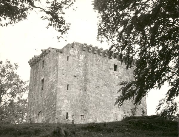
The castle at the Alton which still stands today was built in middle of the 15th century by Herbert de Maxwell. This was a defensive structure, originally having a portcullis and drawbridge and being surrounded by a ‘ward’ (level outer area enclosed by an outer wall) Quarrels between landowners and the big families were common and the times must have been sufficiently dangerous for King James II to grant permission for the castle to be built.
In 1621, the Newton became a Burgh of Barony. This meant it could have a market place and a market cross and hold a weekly market on a Thursday. It was also allowed two fairs a year; on the 4th July and the 15th October. The Newton began to overtake the settlement at Kirkhill in importance.
Life for people ordinary people in Mearns must have remained relatively unchanged for centuries. People lived mostly by farming. We have a poll tax roll from the 17th century which shows that people were living in small clusters known as fermtouns, each comprised of two or three families at most. In a few places, Broom, Flenders, Malletsheugh and Newton there were bigger groups of people. These small communities would live off the land and sell or trade any excess produce.

In the 16th century local people faced considerable upheaval due to the Reformation and the strife which followed. The Maxwells of Mearns along with the Montgomeries (major landowners in Eaglesham) opposed the Reformation for a long time. However, eventually they like others before them gave in accepted the new ways.
Things did not settle for long however, and Mearns, like the rest of Scotland, became a hive of unrest after the National Covenant was renewed in 1638. Many of the major landowners for example, the Earl of Eglinton, the Mures of Caldwell and Sir George Maxwell of Nether Pollock supported the Convenanters, and illegal open air conventicles became common. Minister, William Thomson of Mearns was turned out of his home in mid-winter for refusing to conform, and people could be hung or shot if suspected of holding conventicles. Mearns had its share of martyrs, including John Shields of Titwood and John Parker of Busby, who were beheaded after the battle of Rullion Green. At one point Mearns Castle was garrisoned with troops in order to suppress the covenanters.
Industrial Revolution
The biggest change in the life of people in Mearns came in the 18th century with the Industrial Revolution.
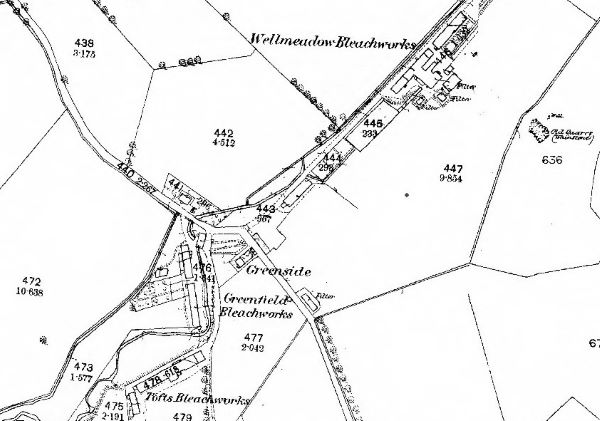
East Renfrewshire, with its network of rivers was an ideal place for the growth of the textile industry. Some of our villages and towns, such as Busby and Thornliebank grew up as busy industrial centres where nearly everything revolved around mills, printworks and bleachfields. Mearns continued to remain largely agricultural but still became home to several industrial undertakings. In 1796, bleachfields were open at Wellmeadow and Broom, employing 65 people between them. Within a few years, there were seven printing and bleaching works as Balgray, Greenfield, Hazelden, Netherplace and Tofts were added. By the middle of the 19th century. there were about 500 people in the area employed in this type of work. The map below is from c.1856 and shows Wellmeadow, Greenfield and Tofts.

As well as textile works, there were also quarries at Brownside, Alton, Kirkhouse, Crofthead, Fingalton and North Hillhead.
This new industry attracted people to the area. Some of the workers lived in Newton but many of them lived in rows of cottages near their workplaces, purpose built by their employers. As there were lots of single women arriving from far afield looking for employment, ‘women’s houses’ were common.
Many people coming into Mearns to seek employment came from Ireland and from the Highlands, driven there by a variety of factors, including the Great Famine in Ireland and the Highland Clearances. As a result the Catholic population of the general area began to rise once again. At first Catholics from Mearns had to travel to Glasgow to worship until 1856 when a church was opened in Eaglesham. This served people from Mearns, Busby and Clarkston with most people travelling there by foot.
The good supply of water in the area which was so vital for the textile industry was also ideal for the supply of household water to a growing population. The Gorbals Gravitational Company, an independent company establised to supply water to areas south of the Clyde, commissioned a series of reservoirs on the Brock Burn.
Between 1847-48, the reservoirs of Ryat Linn, Littleton and Waulkmill Glen were created and in 1850, Balgray Reservoir was commissioned. By 1863 it was providing over 3 million gallons of water a day, which fed areas south of the Clyde including the Gorbals, Barrhead, Nitshill, Pollokshaws , Govan and Rutherglen. By this time the Gorbals Gravitational Company had been bought over by the Glasgow Corporation Water Works.
Despite the industrial influence, farming remained very important in Mearns. Much of this was focused on dairy farming which produced butter and buttermilk for sale in Glasgow. Around 1900, there were about 80 farms in Mearns. Today their names are still recognisable in street and place names eg. Knowes Road, Blackhouse Avenue, Netherton Road and many more.
The 19th century
During this time of rising population and growth, the village of Newton continued to develop as the central focus for Mearns. In 1832 Kilmarnock Road opened (we now know it as Ayr Road). Previously, the main route through Mearns had been the Old Mearns Road which passed through Mearnskirk, but not the Newton. The new road began to draw people and trade away from the old route towards the Newton, contributing to its growth at the Alton’s expense.
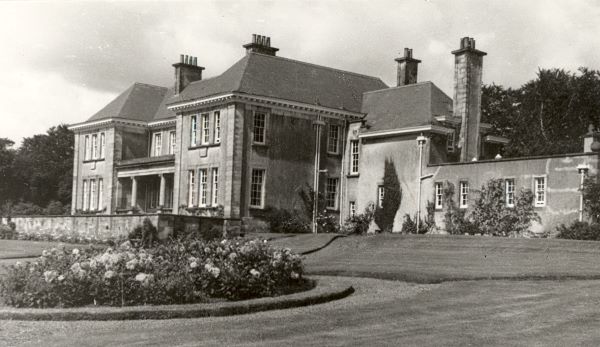
From the middle of the 18th century onwards more and more of the surrounding land was being purchased by prosperous merchants and business men striving to emulate the landed gentry. They wanted to build grand mansionhouses and create landscaped estates where their families could enjoy a luxurious lifestyle, in a country setting. Many example of these fine buildings survive in the Mearns area. Capelrig House, now in the grounds of Eastwood High School, was built by a Glasgow lawyer, Robert Barclay. Greenbank House was built by a Glasgow merchant, Robert Allason in 1764 and is now owned by the National Trust for Scotland. Sadly, some of these beautiful buildings are only a memory. Barcapel House, seen in the image below, was built by St. Thomas Clement in 1912 and burned down in 1965. Luxury apartments now inhabit the site. These ‘big houses’ provided an important source of employment for local people as their vast size required a staff to manage and maintain them: maids, cooks, gardeners, coachmen, to name but a few.

The 20th century
By the end of the 19th century the textile industry had declined and with it, so too, did many of the local towns and villages. However, Mearns like other areas began to transform itself once again.
With improving transport and communications, previously hard to reach rural areas became easily accessible by only a quick train journey from Glasgow. Although train stations at Whitecraig and Patterton did not open until 1903, nearby Giffnock Station opened as early as 1864. Horse-buses were run to and from Mearns village to connecting trains at Giffnock station by Thomas Porter, who owned the village inn. In 1886 a telephone service was set up, further improving communications.
It became much easier for people to work in Glasgow and live in Mearns and like many other local areas it began to form an identity as a commuter suburb. In the 1930s, the upmarket Broom Estate was built by Mactaggart & Mickel, and bungalows began to appear all along Ayr Road from Broom to Newton Mearns. Other building occurred to the north east and south east of Mearns Cross. The advent of World War II called a halt to all this building but after the war it began again in earnest.
There were still however, opportunities for local employment. One notable success was Anderson’s Garage which opened in Newton Mearns on the Kilmarnock Road, near the cross, in 1904. They were agents for Humber Cars and also operated as a vehicle repair business. The firm was originally established by William Anderson as a firm of coal merchants in 1832 in Spiersbridge, before moving into the motor business. Later the firm diversified into engineering, buying in the car chassis to which they then added a vehicle body. Anderson’s was a major employer in the area and at its peak had a work force of over 100.

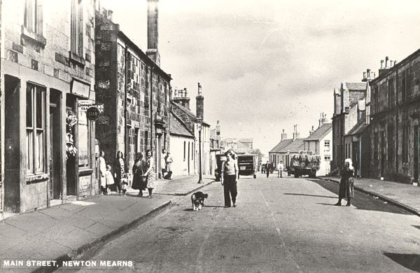
At the same time that housing was growing up all over Mearns, the original old village of Newton Mearns was deteriorating. Many of the buildings that had originally housed textile workers were run down or lying empty. The centre of Newton Mearns was very different in the past, with the Main Street actually behind and running parallel to Ayr Road. During the 1960s, Sir Ian Mactaggart had gradually bought up all the older property in Main Street, and in the 1970s it was flattened and replaced with a modern shopping centre.
Today Mearns remains a pleasant suburban area with good schools and amenities and access to several parks and open spaces. The Avenue Shopping centre still sits at the centre with a good variety of shops and businesses spread across the wider area.
Further Reading
Fairest Parish: A history of Mearns, Eastwood District Libraries, 1988
Loudon, Anne, Old Newton Mearns, Stenlake, 2001
Scott, A. Boyd, Old Days and Ways in Newton Mearns, 1939
Strang, J. A., A History of Mearns Parish in Three Parts, London, 1939
Welsh, Thomas C., Eastwood District History and Heritage, Eastwood District Libraries, 1989
Williams, Lesley, Mearns Matters, Stenlake Publishing, 2003
